That local landmark to which I referred over the weekend

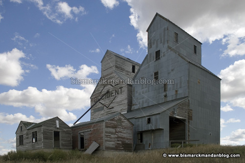
It may not be well known to Bismarck-Mandan folks, but I’m sure anyone from Almont and much of New Salem know about the old Occident Elevator. I previously featured this elevator in my “Occident by Accident” post, after I stumbled upon it while out snooping in the truck. I love those full day photo excursions, and I hope to take another one soon!

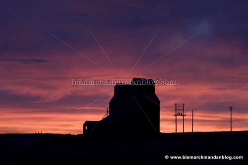
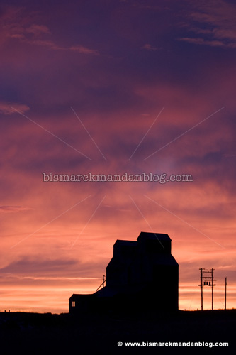
The location of this elevator, for those of you with a GPS, is 46°50.429″ minutes North by 101°30.460″ West. Here are some other photos from the morning, featuring one of the reddest skies I’ve seen.

Here we can see the transition from the red horizon to the bluish sky above. The colors of these sunrises and sunsets can fall off pretty quickly, depending on the sun’s position relative to the horizon.

Not only was it red, the clouds were pretty dramatic as well. The best sunrise in the world is one where the clouds are doing all kinds of exciting things. This morning was exceptional.

Wow. As amazing as these clouds and colors are, somehow they lack impact without a noteworthy foreground object. The elevator pulls it off nicely.

I hadn’t planned on going out for pictures this particular morning, but I’m glad I did. I got to the location at exactly the right time, neither too early or too late. Once it was over, I pointed the truck back to the house to play with my boys. What a remarkable morning!

Amarillo – no, wait – New Salem by Morning

Before things clouded up this morning, there was a fantastic sunrise. I’ve photographed most local landmarks over and over and over, so I figured I’d get outta town a little bit.

Little baby Jonathan was up and down all night; therefore, so were his mommy and daddy. I’d just finished a shift with him and gone to bed at around 5:30, sleeping until 7:00. Stacy was feeding Jonathan, PJ was sacked out, so I hopped in the truck for a little bit. I found myself west of town a little ways, and I wasn’t disappointed. The sky grew pink as I bolted toward a familiar landmark, one which I’ll post later this week. I stopped to take a panoramic photo of New Salem along the way. Sorry, no cow. There’s more to this sleepy little town than a big hunk of fiberglass named Sue.

Occident by accident

I took off early from work last Friday and went off on one of my notorious photography drives, exploring the little nooks and crannies around our fair cities. I was west of Mandan a little ways when I noticed this abandoned Occident elevator just outside of Almont. Okay, so I was more than a little west of Mandan!

This particular day I was capturing photos of a lot of Fallen Farm photos as well as old farm equipment and other North Dakota scenery, but I never thought I’d find an abandoned elevator. Using a circular polarizer filter on my lens, I was able to get a nice blue sky with clouds that really ‘pop’ out of the blue. As I do with a broken-down farm house or barn, I felt a touch of sadness that this big structure was no longer in use.

Road to the edge of the earth

I was working out of state this past week and, on my way back home, got to enjoy Highway 85 through South Dakota. Wow. I don’t do a whole lot of traveling that would introduce me to a long, straight shot through sparsely inhabited territory. At times one can see miles ahead, with the straight ribbon of road visible all the way to the horizon.

I made good time but, since the rest of the crew was with me, I was unable to stop and take any pictures. We were all in a hurry to get home after a long week. I’ll have to make a special trip for that. It sure is good to be back in North Dakota though!

Mandan should have one of these

This is a view of the Red River between Fargo and Moorhead. There’s a really cool recreation area just south of the Main Street bridge where people can wade out among the rocks and fish or just cool off. The banks are landscaped and, in some places, paved with concrete. It looks like a fun place to spend an afternoon.

Here’s a little closer look so you can see the foot bridge crossing the river upstream a ways. I think Mandan should do something like this on the Heart River; there’s a similar area beneath the Highway 6 bridge that would be perfect, and it’s already next to a developed park. Obviously this wouldn’t work with the Missouri, but the Heart River is just begging to be used for some recreation. Anybody got a bunch of rocks they wouldn’t mind dumping overboard?

Up and on my way

The title of this post is a tribute to one of my favorite songs by the group Grasshopper Takeover. A friend of mine and I were, in fact, up and on our way at 4am Saturday morning, after a mere 45 minutes of sleep Friday night. The destination: western North Dakota, both units of the Theodore Roosevelt National Park, and a drive skirting the National Grasslands. The photo above was actually taken a short while after leaving Bismarck. That’s the moon on the horizon, not the sun! By exposing the photo for a little longer, the night sky came alive in the same brilliant orange we’re used to seeing during the sunset.

Once we got to the South Unit, it was time to chase some wildlife. This gigantic beast, however, was standing near to the parking lot. Not too near, thankfully; thanks to a telephoto lens, I didn’t have to live too dangerously.

I was hoping this little dispute would turn into a full blown fight, but these two guys worked out their differences after only a couple of taps.

The most dramatic scenery of the Badlands is the erosion. Erosion formed this incredibly beautiful area, and erosion constantly transforms it. What’s nice is that we can go hiking around in it. It really is more fun to see and experience firsthand than it is to photograph it.

There are herds of wild horses roaming the South Unit, one simply needs to know where to find them. The more exciting of the bunch required a little bit of hiking. Okay, a LOT of hiking. Thanks to the GPS attached to my camera pack, we were able to find our way back! It was great to actually get out into the Badlands on foot for a while.

Of course, there were lots of different flowers. I’ll only post one, but there were indeed quite a variety of different flowers. They stand out against the sand and clay of the soil, to be sure.

The sky was active that day. It was clear in the morning, cloudy in the afternoon, and the sky varied from hour to hour. These clouds looked like a set of venetian blinds across the sky.

I was able to add to my Fallen Farm series with this old farmhouse, sitting adjacent to Highway 85. What was even better was the dramatic sky above; the clouds were starting to really twist and twirl as a storm front approached from the northwest.

In the North Unit of the TR park we were unable to spot much for wildlife. They don’t have horses, and the buffalo were hiding down by the campground. There was a lot of beautiful scenery, however, and we took it all in. This particular rock is sitting a couple hundred feet above the floor of the canyon. I could have climbed over to it and tipped it off its perch. Believe me, I thought about it for a while. Anybody would be tempted, of course, but I wouldn’t want to ruin the view for other people. Thus it remains in place.

Oh yeah…the wildlife. I was hoping for a rattlesnake, inspecting all sorts of rocks and flats. Sadly, although my friend wasn’t disappointed, we never did find a snake. I did, however, find this little lizard. He darted up the rocks as I approached the area, which instantly caught my eye. We took a few pics of him from different angles, then he scrambled into the gap between the rocks.

By 6pm or so we were ready to head back. I’d hit my second wind, third wind, and fourth wind already, due to my lack of sleep the night before. We clocked five hundred miles on the road, hiked a few miles if we totaled up all the walking, had a fantastic pizza in Medora, and guzzled lots of water and pop. I took this shot on Highway 200 as we were cruising down the road. It was a fantastic trip. I slept like a rock Saturday night as a result, and have hundreds of photos to search through. So what did you do this weekend?

Antique rollover

Along Highway 1806 this weekend I spotted this old truck on its side along the railroad tracks. How long it’s been in such a state, who can say? But it made a pretty nice photo opportunity. Its wheels have long gone missing, so it’s unlikely to be removed anytime soon. I guess it’s actually a pretty nice decoration, in a rural sort of way. Just as I’m intrigued by abandoned farm buildings, old vehicles like this really catch my attention as well.

One thing that’s nice about a relic like this being hidden in rural North Dakota is that people are less likely to pry parts off of it for eBay! Although I notice that the trim rings are gone and the hood is open. To investigate further would have meant hopping a fence line, and I didn’t have permission to be there. No worries, I was in perfect position to get the photos I wanted, and this is one of them.

Twin towers – well, one’s smaller

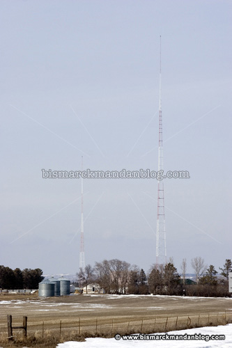
If you’ve ever traveled I-94 east of Bismarck, and you’re likely a hermit if you haven’t, you’ve probably seen these two towers just north of the Menoken exit. I was in the area recently, walking around a waterfowl production area looking for photos, when I saw these familiar towers.

When I first started at the now-extinct Meyer Broadcasting in 1990, the employee handbook boasted the KFYR AM 550 tower as the tallest free-standing radio at the time it was built. I don’t know how it stacks up now, but it’s a pretty tall structure. The “stick” towers you see held up by guy-wires are much much taller, but that’s because they have lots of additional support. These beasties here are built on top of big insulators and have no wires helping them stay upright.

AM radio towers are different than others in that the tower is the antenna. An FM or television “stick” is simply a tower with an antenna at the top of it. So you don’t want to be anywhere near an AM tower while the transmitter is operating!

The little tower is an interesting feature. AM radio signals travel using “ground wave” propagation during the day, but at night the sky’s ionosphere changes and reflects AM radio waves back to earth. That means an AM station can be heard a LONG ways away. So what if there are two 550 AM stations? There are actually a lot more than two, but two high-power 550’s near each other’s range of operation could run into problems if their signal areas suddenly grew at night and overlapped each other. That’s why many stations, including KFYR, “go directional” around sunset each night.

The little tower is energized and “pulls” the signal toward Bismarck (away from Canada, rather) so that it does not cause interference with the other 550s north and east of us. By controlling the power to each transmitter, the engineers can “shape” the signal area in such a way as to avoid interference. Pretty cool, huh?

These days, the transition back to “non-directional” happens during the PH Phactor in the mornings. As sunrise comes earlier, that’ll start to get done before Phil takes the board. But you’ll know the switch is happening when you hear a burp of static for a second or two, then the signal returns to normal.

Tourism at 65 mph

Whenever I see a scene like this, I can’t help but exclaim, “Oh, deer!” Nobody ever finds it funny, though. This was taken from the work van near the entrance to the Badlands National Park in southern South Dakota. In reference to the headline for this post, I need to clarify that we slowed down for this particular picture.

This one, however, was easily taken at 65mph. That’s because Bear Butte is so enormous! It’s a state park site and stands all by itself in the middle of the prairie. It can be seen from a long ways away, and stands out as if it were much taller. It’s over 4,000 feet elevation, which I would guess is a little over 1,000 feet tall. At highway speed it’s hard to make more specific estimations.

These were some wild clouds, almost forming a grid across the sky. My time in South Dakota involved temperatures in the sunny 70s, but the trip home was a cold, windy one. These clouds probably illustrate a pressure wave in the atmosphere as cold temps push their way southward. Thanks, Canada!

I grabbed a pile of tourism information for central and western South Dakota, and I plan to take my wife (and son, once he arrives) for a nice vacation through many of the areas I witnessed at highway speed this week. Sure, there’s a lot of “tourist trap” stuff in the Black Hills, but it’s pretty easy to see through that. Even in the middle of “nowhere” in rural states like the Dakotas, however, there are always breathtaking sights to see. Next time, when I’m not on a tight schedule, I’ll be going a lot slower than 65 mph…with frequent stops.

There’s a story behind every picture

This is my best result from our Photo Club day at work this month. Our assignment: bridges. While I had the most distant one, the other guys bested me in creativity. That’s okay, I had a little bit of adventure:

Beneath one of the bridges I photographed, quite a ways from this one, I found a bunch of electronic equipment. It was the kind of thing a DJ or band would use: racks, amps, pedals, wireless gear. It had been unceremoniously dumped from the bridge and was lying far below, smashed along the rocks.

I climbed down to the smashed remains of the equipment, found a piece with the sticker of a local company on it, and called the phone number it contained. They said they’d go to that bridge and check it out. I haven’t heard back whether it’s their gear, or something they sold to some other unlucky person. In any case, it’s all a total loss and it will NOT be easy to carry up the wall of huge rocks to get it out of there.

So, there really IS a story behind every picture!