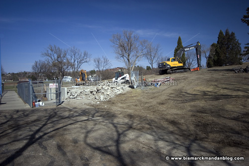
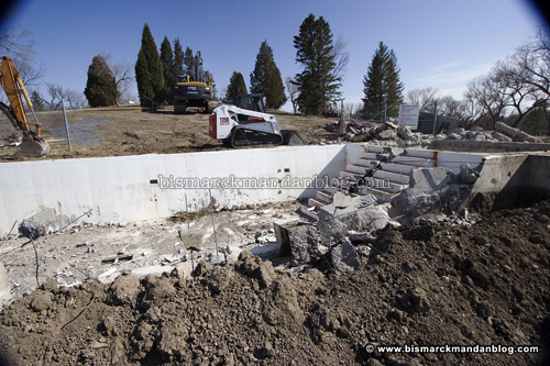
Well, it’s official. We need a new slide

I hope this means we’re getting a new waterpark! I know this is going to be sad news for those who grew up with the water slide at Hillside Park, but it is no longer there. It had aged beyond repair and the kids had figured out how to launch over the side, so it was time for it to go. I guess the pool is staying, though.

This is all that’s left. I have heard talk about people wanting to get an aquatic center like Dickinson has, and that’d be a welcome addition to our list of recreational facilities in this town. For now I guess we’ll have to go to a hotel or the Mandan Community Center and ride the indoor slides, which are much smaller but still fun.

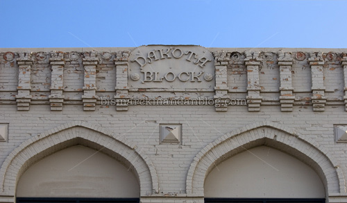
Identify that facade…just don’t drive while looking up, please

I sometimes bemoan the fact that many of Bismarck-Mandan’s historic buildings are falling to the wrecking ball and bulldozer (and, in some cases, a skidsteer on the second floor!). That’s why it’s important to appreciate them while we’ve got ’em. I haven’t posted many of the photos I have taken of unique local building features, but perhaps I’ll do more of that in the future. This could be akin to my “identify the statue” posts that I have done until I started running out of statues.

I left the building name intact on this one, so it should be pretty easy to find. Can you identify this building?
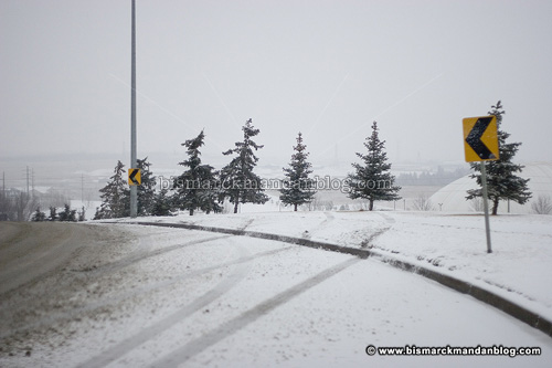
Someone always kisses the lightpost

Gateway Avenue is the street that goes past Basin Electric on its way from State Street to 19th Street. At the crest of this hill the road curves to the left a little, and it’s off camber as well. Naturally it becomes very treacherous when icy, as a couple of people found out tonight.

I’ve never made contact with either the lightpost or the tree, but I did discover the danger of this curve early on in my driving career. Thankfully I filed that information permanently in my melon, because it was particularly slick there tonight! In fact, I saw a 4×4 go by all stepped out as they tried to avoid the curb. Unlike the people whose wheel tracks appear in this photo, they were successful. The person who connected with the lightpost left some parts behind!

Out at the boneyard

In what was perhaps Jonathan’s first photographic trip with his daddy, I captured a photo of the boneyard out at the Mandan Airport on a cold, windy day. Obviously it wasn’t during the super-cold snap we’re experiencing this weekend; I wouldn’t take a baby out in such weather. I think this was about a week ago, when little PJ was visiting his cousins and Jonathan and I took mommy’s new SUV out for a spin.

As you can see by the horizon, it was a pretty bleak and dreary day. I figured that would be a good time to capture this pile of aircraft parts. I took some of the color out of the shot in Photoshop to help the effect.

I’m adding to a boneyard of sorts myself this weekend, one of computer parts. My system drive on my video/graphics workstation in my home office is full, and I have a new stompin’ video card to put in it. That involves prying my computer tower out of its niche in my work area, blowing dust out of it, removing the old system drive and video card, putting in the new ones, and installing EVERYTHING from scratch. Fun.

So far I’ve got the new hard drive and video card installed, a couple of cooling fans replaced as well, and everything blown dust-free. I’ve got Windows re-installed along with the networking essentials: Firefox, Thunderbird, and iTunes. Sunday I’ll start working on my application software.

I have a computer tower with room for lots of hard drives, and I just about have drives A: through Z: now! My workstation has three 200GB drives, one 300GB drive, a 40GB “temporary files” drive, two 300GB external drives, and a 250GB external drive. I have a big server tower in my basement that helps heat the laundry room, too. One can never have too much hard drive space! When working with video and high-resolution photos, most days it’s hard to have enough.

Frosty Sunday

Sakakawea wasn’t the only one taken aback by the frosty, fogged-in capitol building today. There were plenty of us poking around the grounds, even in the early afternoon. I wanted to make it during the morning hours, but was unable to do so before church. I bolted to the capitol immediately after church, and found that the cold temperatures had kept the frost completely intact. There were a few other people poking around with cameras as well.

Somehow, I imagine this is exactly what it was like to be a pioneer some days…braving bitter cold in search of a better life. Thankfully I had the warm truck in which to warm my frozen fingers, because even a few minutes of working the camera made them painfully cold.

This wrought iron horse was a remarkable sight as well, with the gaps in the re-bar sealed with a frosty glaze. I had all but forgotten this statue, but it caught my eye as I rounded the capitol mall. I actually came back later to try a different technique with this statue, and there were still people taking pictures of it. The effect I wanted was to keep the background out of focus, allowing the horse to stand out a little better. It wasn’t easy; I need to get a neutral density filter. I was unable to keep my aperture wide and still keep a slow enough shutter speed to sync to my external flash. I used a lens that tends to help with depth of field, then exaggerated the blur a little in Photoshop.

Check this out – only one side of the horse is frosted! I got the horse at a funky angle here, and I’m not sure if I like it or not. It was accidental; I was paying more attention to other details at the time, so I could get back in the truck and warm my fingers, and get home to my wife and boys. Little PJ has been spitting up, so she kept the boys home from church this morning. Let’s just call the angle ‘artistic’ and not tell anyone, okay?

I also got some other neat frost pictures near the river, but those can wait until another time. As far as I know, the frost is still out there, since the temperatures are cold enough. How long it will last is anybody’s guess…I’m just glad I was able to get out there with my camera to capture it!

Something wrong with the Beacon?

I guess I’m going to have to ask around. The past few evenings I’ve noticed that the Weather Beacon is dark. Hopefully it’s not in need of another costly major repair!

I have the honor of having been one of the folks charged with changing the color of the Weather Beacon to reflect the current forecast. In the 1990s when I worked in Master Control at KFYR-TV, the switch box for the Beacon was right behind where I sat at the control board. There were six clunky push buttons on the box, one for each permutation: red, flashing red, white, flashing white, green, and flashing green. The program log for KFYR-TV had occasional reminders throughout the day/night to check the Beacon.

Later on I heard that the control reverted to KFYR radio, and I think there was a span in there where nobody was really controlling it. I think each station thought the other was doing it! That would have been around the time that the radio stations’ headquarters moved out of the Meyer buildings.

I also got to help Save the Beacon back in the 90’s too, as KFYR’s webmaster, but that’s a story for another time.

Out to pasture

On a lonely little gravel road west of Mandan I found this rig parked in the corner of a field. As anyone visiting this site on a regular basis knows, I’m a sucker for a broken-down farmstead, a windmill, a well, or an old farm implement. I guess it’s part of North Dakota’s charm, although a wistful one at that. In my travels around the periphery of Bismarck-Mandan I’ve found many such sights, more than I’ve posted here. Gradually I’ll let ’em all out!

Main Avenue color

You don’t need to go far to find some beautiful fall foliage in Bismarck. A while back I found these leaves, and many other colorful varieties, right on Main Avenue! In fact, the blue behind them isn’t even the sky; it’s the back of the sign of the office building at the corner of Main and Mandan Street. I can’t believe I spaced the name of it…wait! It’s Tuscany Square.

One interesting thing is that the map graphic on the home page of the Bismarck Historical Society lists east-west roads as “Streets” and north-south ones as “Avenues.” For instance, there’s Washington Avenue and Sweet Street. The map is from 1883, so something must have changed in the 125 years since. Main Avenue, however, is listed on the map as “Main A”…so perhaps it has never been Main Street.

The other side of Double Ditch

I’ve posted a few sunset photos from this vantage point: the post at the north border of Double Ditch Indian Village, perched atop the cliff. It’s a popular point of view for local photographers, and I’ve run into a few there. But it brings up the question of what this area looks like from below.

It’s been a while since I’ve been down at the bottom of these cliffs. Back in the 1980s there used to be a big sandbar island in the middle of the river here, and we’d have big parties out there in August to say goodbye to friends before everybody left for college. We’d have a generator and sound system, volleyball nets, and boats ferrying people to and from the shore. Those were the days. So I decided to find the old foot path down to the river and poke around a little before sunset.

Wow. The path has eroded some. A lot, actually. It’s at the south end of the road now, which used to be the midpoint of the park when the road looped all the way through. Despite having a few grand worth of camera gear on my back, I decided to skate down the trail anyway. I managed not to tip over and only got a little bit muddy at the bottom, where natural drainage brings water down to the river from the hills above.

Wow, I came down that wearing a pair of Airwalks? I’m braver than I thought! I figured I’d come up with a plan for getting back up the hill later, since I didn’t even have enough traction to get down gracefully. Getting back up this way seemed highly unlikely.

Of course, that’s when I noticed a trail nice enough to call wheelchair accessible coming down from the other side of the ravine! It wasn’t exactly visible from where I came down, and seems to be relatively recent since there’s a little signage area at the top, part of the “new” park. I haven’t spent much time hoofing around the park since they took the road out, so it had escaped my attention until now. At least now I know how I’m getting back up!

The water was calm that day, my friends. There were actually a lot of graceful ripples lapping at the shore, and that is a REALLY nice sound. I had my iPod in my pack, but this time I left it there. It was a nice little meditation walk this time, something I haven’t done in way too long. The sky wasn’t really doing anything of note, so I decided to head north and investigate the shoreline along the park.

The Missouri River is low right now, as you can see. I had no problem walking on recently solid ground among fallen trees and other debris, but nothing really mindblowing. I did see some beverage cans that were old enough to be the pull-tab type from the 1970s, a C02 cylinder from a fountain pop dispenser, and a rusty 55 gallon drum. There were a lot of interesting tracks, too.

Of course, this wouldn’t be Double Ditch without any of the fabled cars at the bottom of the cliff! The grass was really tall, but I spotted at least three of them. There might even be some trim pieces on a couple of these that would be worth something on eBay. Did I just give you some ideas?

Remember that post I told you about? Here’s how it looks from a hundred feet below. of course, I zoomed in so it was actually visible in the shot. Considering the condition of these cliffs, I’m going to be a little more reluctant to stand right at the edge!

About this point, the sun was a distant memory over the horizon and I was getting cold. I didn’t have any gloves, was wearing only a light jacket and could see my breath. That’s what happens sometimes with these spur of the moment trips, I guess! I worked my way back, hands stuffed firmly in my coat pockets to keep warm, and walked easily up the established trail. I cranked the heater in my truck, dodged deer all the way back into town, and called it an evening. While I didn’t really come away with any jaw dropping photos, I still call the trip a success; it’s an angle of Double Ditch I’ve been meaning to see for a long time.